


When aging infrastructure and undersized drainage structures began causing repeated repairs and flooding in a key commercial corridor, the Puppy Dog Coulee Storm Sewer District faced a complex challenge: how to modernize a critical drainage system with the least disruption possible to businesses, residents, or daily traffic. This project delivered a long-term solution that improved flood protection, restored public confidence, and removed surrounding properties from FEMA-designated floodplains.
PUPPY DOG
COULEE
PROJECT SNAPSHOT
PRIMARY GOALS OF THE PROJECT
-
Eliminate roadway and property flooding
-
Replace failing infrastructure
-
Remove residential and commercial properties from FEMA floodplains

The Challenge:
Aging Infrastructure & Floodplain Impacts
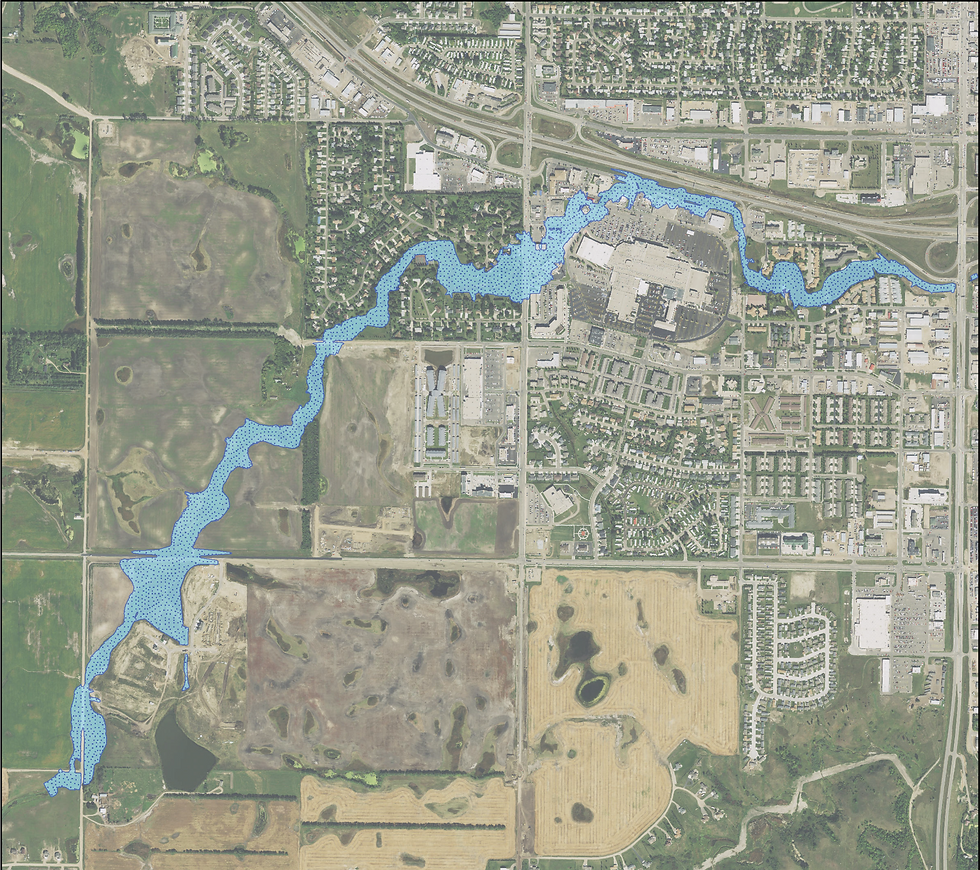
For more than 40 years, stormwater from a large portion of Minot flowed through two 84-inch corrugated metal pipe (CMP) culverts beneath the Dakota Square Mall area. While the system had served the community well for decades, time and changing storm conditions had pushed it beyond its intended limits.
The culverts were severely corroded and structurally deteriorated, requiring regular inspections and repeated repairs just to remain operational. In addition, they were hydraulically undersized for modern, FEMA-modeled storm events. During major rainfall events, the culverts could not pass stormwater fast enough. Water over-topped a principal arterial roadway, flooded an upstream residential subdivision, and spilled into adjacent commercial properties.
AFFECTING MORE THAN JUST THE DAKOTA SQUARE MALL AREA
What was less obvious was Puppy Dog Coulee drains runoff from nearly 15 square miles upstream of the Dakota Square Mall. The culverts lacked the conveyance to prevent residential flooding upstream. As a result, residential properties upstream of the project experienced higher flood risk. The inadequate conveyance resulted in higher flood elevations which caused properties to be mapped within the 100-year floodplain in previous studies.
At the same time the culvert replacement was being evaluated by our team, FEMA was updating floodplain maps for Puppy Dog Coulee and the rest of Ward County. Many residential and commercial properties were shown within the updated 100-year floodplain, triggering increased flood insurance requirements for property owners. A primary design goal for the new culverts was to lower 100-year flood elevations upstream of 16th Street SW, allowing homes to be removed from the updated flood insurance risk maps while also addressing the long-term condition of the infrastructure.
Understanding the Basin: Hydrology and Floodplain Analysis
Before a solution could be designed, the drainage basin needed to be fully understood. The project team completed a comprehensive hydrologic and hydraulic analysis using FEMA-accepted methodologies. A HEC-HMS model was developed to evaluate watershed runoff characteristics across the 15-square-mile basin, while HEC-RAS was used to model system hydraulics and existing floodplain conditions.
These models allowed the team to:
-
Identify the culvert capacity required to eliminate roadway flooding
-
Establish flood elevations impacting surrounding properties
-
Evaluate how proposed improvements would affect FEMA floodplain mapping
The analysis ultimately supported the preparation and submittal of a Conditional Letter of Map Revision (CLOMR) to FEMA, a key step in removing affected properties from regulated floodplains. Upon completion of the project, a Letter of Map Revisions (LOMR) will be submitted to FEMA, which will remove the affected properties from the floodplain.
Why Simply “Going Bigger” Wasn’t an Option
Initial calculations made one thing clear: replacement culverts would need to be significantly larger than the existing pipes to meet flood mitigation goals. However, maintaining the original alignment presented major obstacles.
The existing culverts ran between two active strip malls. Constructing a much larger system in the same location would have:
-
Severely restricted access to operating businesses
-
Required construction in extremely tight spaces between buildings
-
Proven physically impossible given the required culvert dimensions
Adding to the challenge was limited available grade. Extending the system too far would flatten slopes, reducing hydraulic performance and undermining the very improvements the project was meant to achieve.
In short, the solution wasn’t just about size—it was about finding a buildable path.

Evaluating Alternatives: Balancing Performance and Practicality
An alternatives analysis was completed to identify feasible alignments that balanced:
-
Hydraulic performance
-
Constructability
-
Cost
-
Impacts to businesses and the public
Two primary alternatives were developed:
-
One that increased the culvert length by several hundred feet
-
Another that increased the culvert length by approximately 160 feet
Both required non-linear alignments to navigate existing development. After evaluating each option, the project team selected a preferred alternative that offered the best balance of performance and constructability.
The solution: a carefully designed “S-curve” alignment that shifted the middle portion of the culvert between two buildings, avoiding major disruptions while maintaining hydraulic efficiency.

The Final Design: Large Capacity in a Tight Corridor
The selected design replaced the aging CMPs with twin 12-foot by 8-foot reinforced concrete box culverts, providing the capacity needed to safely convey major storm events.
Because of the curved alignment, the design team coordinated closely with box culvert manufacturers to:
-
Confirm fabrication tolerances
-
Ensure curved joint geometry could be constructed accurately
-
Avoid conflicts during installation
This early coordination helped reduce construction risk and ensured the design could be built exactly as intended.


Construction Challenges and Precision Execution
In addition to a phased construction schedule, wide and deep excavations, tight working constraints between commercial buildings requiring sheet piling/soldier piling and lagging system, one of the most significant construction challenge was maintaining precise horizontal alignment through the curved sections of the culvert. Even small deviations could have caused joint conflicts or structural issues, potentially requiring costly disassembly and realignment.
To manage this risk, the contractor used:
-
GPS-guided construction equipment
-
Carefully surveyed offset controls
This approach allowed the curved box culverts to be installed accurately, keeping the project on schedule and avoiding rework.
PROJECT SCOPE & RESULTS
Wagner Construction served as the prime contractor, supported by multiple subcontractors.
Most importantly, the improvements:
-
Eliminated roadway flooding
-
Reduced flood risk to nearby homes and businesses
-
Delivered long-term, resilient infrastructure for the community
When fully completed, the project will include:


WHY THIS PROJECT MATTERS
This project demonstrates how thoughtful engineering, rigorous analysis, and constructability-focused design can solve complex infrastructure problems in developed areas. By balancing hydraulic performance with real-world constraints, the Puppy Dog Coulee improvements delivered measurable community benefits without sacrificing access, safety, or economic activity.
Additional information on the project can be found on the City of Minot website.